Showing posts with label connectivity. Show all posts

January 20, 2025

Bathurst Complete Street Project

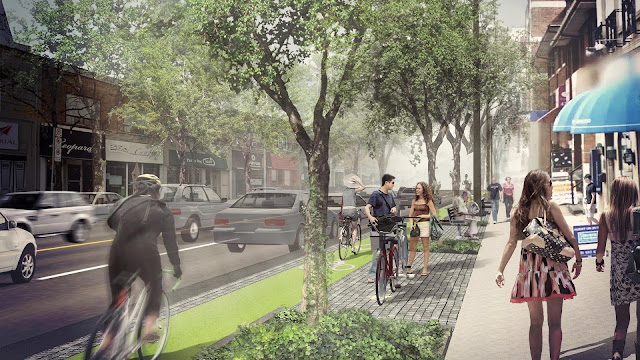
Upon reviewing the North York map for the 2025-27 Bike Plan, one of the most significant projects in the pipeline is the Bathurst Complete Street from Bainbridge to Steeles Avenues. A cycling route which also shows up in York Region’s 2022 Transportation Master Plan. Ahead of the public consultation scheduled for Thursday, January 30 (6:00 – 8:30 PM) at Rockford Public School, let’s look at what this project has to offer, as well as what’s needed to further improve connectivity in the area.

Bathurst Complete Street rendering - Via City of Toronto

June 14, 2022

WTF is up with Eglinton?

The long anticipated Eglinton Crosstown LRT is nearing completion with service expected to start next year. As for what that means from a cycling perspective the City of Toronto recently announced a virtual public meeting scheduled for Wednesday, June 22 under the name eglintonTOday. (Yes, Toronto is addicted to branding everything TO.) Let’s review what this project has in store, how it differs from Eglinton Connects, and what else has been done on Eglinton.
Eglinton Connects rendering (Via SvN)

May 16, 2022

Adapting Maslow's Hierarchy to Bikes

Over the past decade, I have seen how Toronto’s cycling advocacy has evolved. While advocating for painted bike lanes may have been fine back in 2012 – one year before Toronto’s first separated bike lanes officially opened on Sherbourne Street – it certainly is not the case today where the constant threats of parking in bike lanes prompted the need for physical protection. However, advocating for safe streets goes far beyond adding physical protection. To reflect on this exercise, I took a crack at adapting Maslow’s Hierarchy of Needs to cycling infrastructure.

December 09, 2020

Connecting to Kipling Station

On Monday, a virtual public meeting was held regarding a proposal to extend the Martin Grove bike lanes from Rathburn to just north of Burnamthorpe, as well as upgrade the existing Rathburn bike lanes with protection and the intersection at Rathburn and Martin Grove. This is all part of a watermain replacement project planned for next year. I was able to tune in to the meeting and have some thoughts to share.

Rendering of proposed Martin Grove cycle tracks (via City of Toronto)

October 23, 2019

Checking Out Scarlett and Six Points

The Etobicoke York district has two main cycling projects for 2019; those being the protected bike lanes on Scarlett Road and the Six Points intersection in Etobicoke Centre. Scarlett was part of an action plan proposed by the Ward 11 Pedestrian Safety and Cycling Community (now Ward 5 York South Weston), while Six Points – where Bloor, Dundas, and Kipling meet – is attracting higher density development. I biked by these two areas on Sunday to understand the importance of these two projects.
Scarlett cycle tracks at the Humber River Trail

April 26, 2019

My Longitudinal Frustration

Early last year, I switched jobs to near Dufferin and Lawrence and slashed three quarters of my commute distance. During the winter months, I took the TTC but aimed to commute by bike as often as possible (of course). This bike commuting experience made me aware of not only how few bike lanes North York has, but also the lack of dedicated north-south routes in Toronto. Especially north of Davenport. Since I opted to take a different route yesterday morning, I will reflect on that experience, my original route, and a project the City of Toronto is looking to implement late this year.
The West Toronto Railpath was part of my original bike commute

April 20, 2019

Small Changes for a Big Difference

Like many others in Toronto’s cycling community, I am frustrated with our city’s slow pace of bike lane installation. Montréal was able to install 90 kilometres from 2016 to 2018 while Toronto only installed 25 kilometres. As much as we need to push for key projects such as on Bloor and Danforth, a recent announcement for a cycling project revealed how small changes can also make a big difference.
Cycle track on Dufferin while under construction in August 2018

October 12, 2018

Completing the East End Grid

Last month, the City of Toronto installed new bike lanes in Thorncliffe Park and Flemingdon Park. When I had a chance to briefly check them out recently, I found them to be a promising start. However, there are several key gaps which need to be filled in order to truly give a boost to cycling in those neighbourhoods and Toronto’s east end as a whole.
Recently installed bike lanes on Thorncliffe Park Drive

October 01, 2018

Trail Gaps Along the Don

While Toronto’s bikeway network has lots of gaps to fill, east-west connectivity is arguably much better than north-south. Especially north of St. Clair where continuous routes are limited to the Don River and Humber River trails, as well as the bike lanes on Royal York which go to Dixon Road. Back in August, I biked the Don River trail system to Sheppard Avenue to identify trail gaps and better understand how the trail system fits with the Lake to Lake Route.
Wayfinding signage used on the Lower Don Trail

August 28, 2017

A New East End Connection

Bike lanes on Woodbine Avenue
Normally, my bike commute takes me along Richmond-Adelaide and Sherbourne Streets, as well as Danforth Avenue to get to Danforth GO station. Sometimes, I will go home via Bloor and Shaw Streets thanks to the Bloor bike lanes installed last year. Given bike lanes were installed on Woodbine Avenue south of Danforth Avenue during the weekend, I decided to give Woodbine a try and check out other bike lanes which connect the east end to downtown. This new routing also allows most of my commute to take place on dedicated cycling facilities.

January 29, 2016

Twelve Days of Bicycles - Eleven Trails Ablazing

UPDATE (2016/02/09): This post has also been featured in Dandyhorse, which can be viewed at this link.

Until February 15, 2016, stakeholders of the West Toronto Railpath Extension have the opportunity to comment on the Environmental Study Report (ESR). Hard copies of the report exceeding 400 pages (including appendices) can be read at the Parkdale, College-Shaw, and Fort York Libraries, while an online version is also available at http://www.toronto.ca/westrailpath. The West Toronto Railpath is a multi-use path popular with west-end residents which goes along the Kitchener GO corridor from Cariboo Street to the current terminus of Dundas Street West. This first phase was completed in 2008 and won an urban design award in 2011.
Existing West Toronto Railpath next to Kitchener GO Line

December 08, 2015

Twelve Days of Bicycles - Four Lake Shore Spans

From my building in Liberty Village to where the Martin Goodman Trail ends at Norris Crescent, I pass or cross four cycling bridges at Jameson, Roncesvalles, Humber River, and Park Lawn. From Norris to where the trail resumes at First Street, cyclists have to use Lake Shore Boulevard; a busy arterial road not appealing to most recreational users. To remedy this issue, there are plans to install a 1.4 kilometre bi-directional cycle track on the south side of Lake Shore. A public consultation was held this evening at the New Toronto Library with city staff available to answer residents’ concerns.