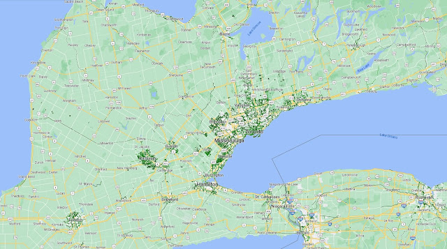
Over the past few years, I have had the chance to ride several regional trails in southern Ontario; starting with the Greater Niagara Circle Route in 2016. I have since done the Oro Medonte Trail from Barrie to Orillia, the Georgian Trail from Collingwood to Meaford, the Brantford to Port Dover trail, the Elora Cataract, and part of the Omemee Rail Trail near Peterborough. However, a look at Google Maps show there are a lot more regional bike trails, along with some significant gaps. Let’s look at some of these regional trail gaps and how they can be filled.
 |
| Map of current bikeways per Google Maps |
The Concept of Rail Trails
Before starting this discussion, I would like to highlight a resource called “Forgotten Railways, Roads & Places”. The website shows abandoned and out-of-service railroad lines across North America. Coincidentally, a lot of these railways were already converted to multi-use trails while there are others which could be converted in a similar manner to fill these gaps.
 |
| Map from Forgotten Railways, Roads & Places |
Niagara Peninsula
The Greater Niagara Circle Route has three of the four legs largely completed along the Niagara River (except for a short stretch within Niagara Falls), Friendship, and Welland Canal Trails. However, the northern end adjacent to Lake Ontario is the missing link to completing this Circle Route (1a), while the Waterfront Trail is also missing between Stoney Creek and St. Catharines. North Service Road would be the most likely candidate for this treatment (1b).
The southern part of the Niagara Peninsula could also use some love. There is a 13 kilometre Gord Harry Trail which – like the Friendship Trail – is part of the former Grand Trunk Railway. However, there is a three kilometre gap between the Gord Harry and Friendship Trails. The Grand Trunk Railway goes further west to Dunnville and Caledonia (2 in red), so converting that should be relatively easy and allow for a connection with the Escarpment Rail Trail to Hamilton.
Going further west to the Brantford to Port Dover trail could use a few options. The first would involve using the rail line from Canfield Junction through Waterford which could go all the way to Amherstburg south of Windsor (3a in purple), while the second is the Great Western Railway from Canfield Junction to Simcoe and on the existing trail to Delhi (3b in purple). A spur from the Great Western Railway from Jarvis to Port Dover (3c) could also be worth considering.
Southwestern Ontario
The 132 kilometre Guelph to Goderich (G2G) Trail may be the better known long distance trail in southwestern Ontario, but the trail using the Toronto Grey and Bruce Railway from Owen Sound to Orangeville is almost as long at 113 kilometres and has the potential to become even greater. While consideration will be needed for a future commuter line to Orangeville, the trail could be extended using the Melville to Bolton part of the rail line (4), the William Granger Greenway in Vaughan – part of the proposed Vaughan Super Trail system – and Toronto’s Humber River Trail all the way to the Waterfront! This trail would also connect with the Caledon Trailway.
The Elora Cataract Trail is currently isolated wit no collections to adjacent trails. To the west, the Guelph to Durham rail line could be used to connect Elora to Guelph which would allow for a connection to the G2G trail. (5a) To the east, a short northern extension (5b) could be done to connect with a future Toronto Grey and Bruce Railway extension which in turn would also offer access to the Caledon Trailway.
Given the relatively short distance between Guelph and Cambridge (approx. 10 kilometres), a trail should be considered to link the two cities (6) and make it easier to access the Cambridge to Paris Rail Trail instead of having to go all the way to Elmira. Finally, the Caledon Trailway could be extended south using the Hamilton and North-Western Railway to Georgetown and then use Highway 7 (or Highway 107) to connect with Brampton. (7a)
Central Ontario
At the other end of the Caledon Trailway at Tottenham lies another great extension potential. A trail exists between Innisfil Heights and Randall, but the rail line goes further south to Beeton. A seven kilometre gap exists between Beeton and Tottenham which was not served by rail lines. (7b)
 |
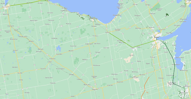
| Stayner to Barrie (8a in light green), Meaford to Owen Sound (8b in light green), Barrie GO Line (9 in dark green) |
The Georgian Trail (Collingwood to Meaford) can be extended from the eastern termimus of Stayner to Angus using the existing rail line and then along Regional Road 90 to Barrie. (8a) A trail parallel to Highway 26 could be considered for a western extension from Meaford to Owen Sound. (8b) This – combined with the Caledon Trailway and Toronto Grey and Bruce Trail extensions – could lead to a great loop connecting Orangeville, Barrie, Collingwood, Meaford, and Owen Sound.
Another gap lies between the Lake to Lake Cycling Route and Barrie. Since East Gwillimbury has the largest unbuilt stretch right now, it could be worth exploring building a trail parallel to the Barrie GO line from East Gwillimbury all the way to Allandale Waterfront. (9) This would offer people a chance to bike from Toronto to Barrie (or vice versa) using the Lake to Lake Route.
Eastern Ontario
Eastern Ontario has two gaps which need to be considered. The first is filling the trail gap between Whitchurch-Stouffville and Uxbridge (10) to allow for a connection to the series of trails leading to Lindsay and Peterborough. The second is the Waterfront Trail between Oshawa and Napanee which is largely disconnected (11); something which can be remedied with the Prince Edward County Railway from Port Hope to Belleville and the Cataraqui Trail from Belleville to Napanee. Filling this gap would offer connections to Kingston (via a spur trail), Smith’s Falls, and on to Ottawa.
 |
| Whitchurch-Stouffville to Uxbridge (10 in light purple) & Oshawa to Napanee Waterfront Trail (11 in dark purple) |
Additional Considerations
As exciting as the potential for these rail trails can be, a trail network of this size would require solid wayfinding and maybe a trail numbering system similar to Québec’s Route Verte. GO Transit also has a role to play in expanding their “Trail To GO” wayfinding system and the eventual expansion of their two-way all day rail service to make it easier to access these trails without a car. Certain cities such as London, Ontario don’t have any long distance trail connections and will need more significant investments to link up with this provincewide trail network.
 |
| Map showing all the trail connections discussed in this post in red |
Are there any trail opportunities I missed? Are there any trails you plan to ride this summer? Let’s hear it!


I don't see any mention of the OBRY line. That was officially abandoned last year, and purchased by the Region of Peel with the intent of turning it into an multi-use trail. That line runs from Streetsville in Mississauga through Brampton to Orangeville. It already crosses the Culham trail along the Credit river in Mississauga, the Caledon trailway at Inglewood, and the extreme east end of the Elora-Cataract trail in Forks of the Credit provincial park. Connecting it to the trail from Orangeville to Owen Sound would be trivial as they were once part of the same rail line.
ReplyDeleteI noted that OBRY line in a follow up post. Would certainly be a game changer.
Deletehttp://www.twowheeledpolitics.ca/2024/06/june-2024-trail-connection-follow-up.html
Barrie owns the portions of the continuation of the trail from Innisfil Heights right to the Barrie Waterfront. They also own from the waterfront out to Angus. The city is operating these sections at a loss so it’s only a matter of time before they are abandoned. They would connect Barrie to (potentially) Caledon to the south and across to Collingwood in the west.
ReplyDeleteWould love to see this happen! I’m a big fan of using old rail trails for cycling which keeps the cyclists safe by being off the highways. Unfortunately our government is blind when it comes to multi-use trails.
ReplyDeleteI noticed in the Ontario government plans for the Uxbridge Urban provincial park, the old rail line from Stouffville to Uxbridge is shown as a trail :)
ReplyDeleteI had just put up a blog post about the Uxbridge to Lindsay Rail Trail when you posted your comment. Will have to update it later today. Thanks for reminding me.
Deletehttp://www.twowheeledpolitics.ca/2024/06/uxbridge-to-lindsay-rail-trail.html