 |
| Eglinton Connects rendering (Via SvN) |
Recent Developments on Eglinton
Several installations happened on Eglinton over the past year which will help make Eglinton a game changer for active transportation. The existing multi-use path has been extended from Jane Street to Prearen Park last fall including a protected corner island. Here’s a picture courtesy of Jun from Biking in a Big City.

At around the same time, a multi-use path has been installed from Weston Road to Black Creek Drive – leaving a gap from Prearen to Weston – as well as buffered bike lanes from Weston to Bicknell Avenue. Thanks Doug Wedel for these pictures.
 |
| Multi-use path near Mount Dennis Station (via Doug Wedel) |
 |
| Buffered bike lanes east of Black Creek (via Doug Wedel) |
Metrolinx has been installing raised cycle tracks in front of LRT stations, as well as between Avenue Road and Holly Street (just east of Yonge Street). I had a chance to check this installation back in March, while construction at Yonge and Eglinton is ongoing at this time.

Further east, the surface portion from Don Mills to Birchmount had buffered bike lanes which don’t make for a safe crossing across the Don Valley Parkway. My understanding from city staff is that barriers are planned to be installed after Metrolinx completes their work.
 |
| Eglinton bike lanes near Aga Khan stop (via Hafeez A) |
What about Eglinton Connects?
When the City of Toronto announced Eglinton Connects – the environmental assessment for which was done in 2012 – the renderings showed raised cycle tracks, improved green spaces, and wider sidewalks. There was also a focus on increasing density along the corridor with mid-rise buildings (and taller ones at key intersections). While Metrolinx is implementing the streetscaping treatment near stations and between Avenue and Holly, the right of way in between stations is constrained including various private encroachments while reconstruction could be several years away. In response to a City Council direction in December 2019 to accelerate streetscaping work on Eglinton, the City created eglintonTOday to allow the quick build of some of the elements found in Eglinton Connects.
What does eglintonTOday have?
Three different design options have been proposed for this project. Keele to Caledonia will see three traffic lanes and no parking, while two traffic lanes will be kept east of Caledonia. Caledonia to Oakwood will see parking on both sides, while Oakwood to Mount Pleasant will only have parking on one side. Sidewalk improvements, parkettes, street art, curb extensions, and CafeTO patios will also be included where feasible.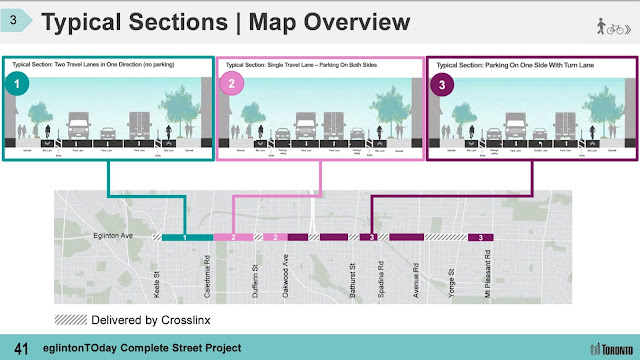

Phase 2 from Mount Pleasant to Brentcliffe will be done at a later date. This part is unfortunate given this would leave a 2.5 kilometre gap with Metrolinx doing the bike lane installations east of Brentcliffe. Why not do it all in one shot?

Comments are due by Sunday, July 31, while council approval and installation will happen next year with a new council that could see at least five new faces.
What needs to be improved?
Aside from the stretch east of Mount Pleasant, there are several connections that are badly needed. One of these I used to encounter biking to work is the jog at Winona-Eglinton-Marlee, as well as completing the Marlee bike lanes from Roselawn to Eglinton. Despite a couple of blocks being narrow there, I was informed this is already on the City’s radar.
Another action needed to boost the bikeway network effect is to extend the Yonge bike lanes one kilometre north from Davisville to Eglinton. City Council voted to extend the complete street pilot until January 2023. The bike lane has been getting more opposition than with Bloor-Danforth, but it still needs to be made permanent and extended. The tripling of cycling volumes on some parts shortly after installation does not take into account the recent trends of people returning to offices, so expect the numbers to become even higher.
A couple of additional connections have been identified by the City which are along Croham Road to connect Eglinton with the Beltline Trail, as well as along Glen Cedar Road to the Cedarvale Ravine Trail.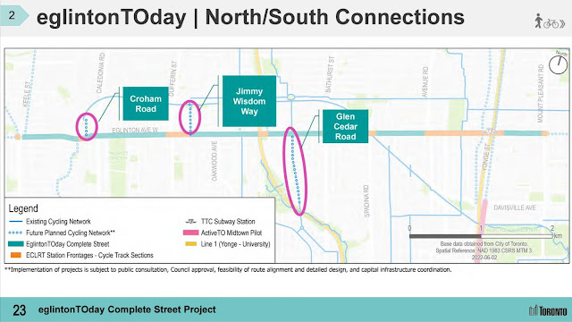

Next Steps
If you are able to, please register for the June 22 virtual meeting or attend one of the community pop up events. Not only do we need to show our support for eglintonTOday, but also demand the necessary connections such as to the Beltline Trail, Yonge Street, Cedarvale Ravine Trail, and fixing the jog at Winona-Eglinton-Marlee. Such a project has the potential to be a game changer for Midtown and we need to ensure we get it right.
Even if you are not able to check out the Eglinton meeting, there are two other road safety related meetings happening this month which you should check out. The Mimico Neighbourhood Mobility Plan one is happening tonight at 6:30 PM, while the Broadview Avenue Extension Environmental Assessment virtual meeting will be on Tuesday, June 21 at 6:30 PM.
LOVE your blog. I've registered for the meeting and want to reiterate how important the built environment is to enabling residents to live active lifestyles. It's easy for public health to put the onus on individuals, but unless there is infrastructure support, it's not easy for people to make the healthy/logical (i.e. it probably takes less time to bike sometimes than drive) choice.
ReplyDelete