Next week’s Infrastructure and Environment Committee meeting will be the last one held before the 2022 election. Upon reviewing the agenda, there are seven items which affect people who bike. Let’s do a quick recap of the projects to bring you up to speed and encourage you to send your submission over the long weekend.
 |
| Map of Yorkdale Transportation Master Plan (via City of Toronto) |
IE31.10 (Yorkdale Transportation Master Plan) – The Yorkdale Transportation Master Plan covers an area from the Barrie GO line to the west, Allen Road to the east, Wilson Avenue to the north, and Lawrence Avenue to the south. The improvements will span over 20 years and is expected to cost between $356 to $458 million; the most expensive part of which involves extending Caledonia Road under Highway 401. Some cycling improvements are called for along Bridgeland Avenue, Yorkdale Road, Cartwright Avenue, and Dufferin Street. Dedicated pedestrian and cycling bridges are also called for crossing both the Barrie GO corridor and Highway 401. Here is a map of the plan for your reference.
IE31.11 (Mid Humber Gap) – During the May 17, 2022 virtual public meeting, the City of Toronto presented their preferred alignment for filling the Humber River trail gap by keeping the trail within the valley and using parts of the Weston Golf and Country Club. Jun N of Biking in a Big City has an excellent overview of the project, while I mentioned the gap in my latest Toronto Star op-ed calling for this gap – and others along Toronto’s Loop Trail – to be completed as soon as possible.
 |
| Preferred Mid Humber Gap Alignment (via City of Toronto) |
IE31.12 (Cycling Network Plan Q2 2022 Project Update) – Four projects have been included with this motion totalling 3.33 centreline kilometres of new bikeways. These include the Gerrard East Complete Street from Sherbourne to Blackburn Streets, Renewing Overlea Boulevard, Martin Grove Cycling Connections, and improvements to the Shuter-River intersection. That intersection will move the eastbound bike lane on Shuter so it’s next to the curb and protected, while a left turn box will be added at River for those wishing to turn onto Shuter.
 |
| River and Shuter Intersection (via City of Toronto) |
Unfortunately, the scope for Martin Grove has been reduced to extending the existing bike lanes north from Winterton Drive to Eglinton Avenue – the protected intersection still made it through – and improving the intersection at Burnamthorpe. The stretch from Burnamthorpe to Bloor – as well as the intersection at Bloor – will require further study to address concerns about school (and parking) access, as well as trail safety and impacts on surrounding streets.
IE31.13 (Port Lands Flood Protection – Interim Road Opening) – With work on the Don River flood prevention project and the new Cherry Street alignment progressing, temporary uni-directional cycle tracks are to be put in on Commissioners from the old Cherry Street to the new one, as well as bi-directional cycle tracks on the west side on the new street. Those on the old street would be removed to allow for the flood prevention work to continue.
 |
| New Cherry Street at Commissioners Street (via City of Toronto) |
IE31.14 (Broadview Avenue Extension) – Since the public consultation for this project happened last week and no material changes were made to the recommended solution since then, you can read more about the project on my blog including some suggestions for improvement.
IE31.16 (Beltline Trail Improvements) – This motion – while only intended to be received as information – provides a clearer picture on how the York Beltline and Kay Gardner Beltline trails will be linked. A dedicated bikeway is called for on Roselawn and Elm Ridge from Marlee Avenue to the Allen Greenway, while the Allen Greenway will get a proper multi-use path for one block to complete the gap. Longer term solutions include extending the Marlee bike lanes and Allen Greenway south to Eglinton, as well as studying the feasibility of a pedestrian and cycling bridge crossing Allen Road. Maybe the Allen Greenway could end up being extended north to as far as Yorkdale Mall / Baycrest Park?

The motion shows another map about a potential extension of the York Beltline Trail east of Marlee to just before Allen Road.
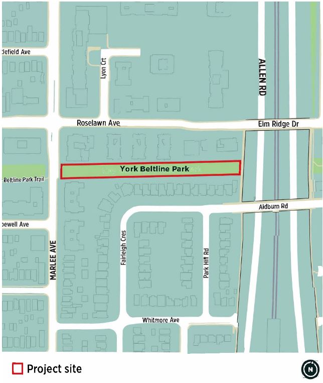 |
| Planned York Beltline Trail Extension (via City of Toronto) |
IE31.19 (Bartlett-Havelock-Gladstone) – Originally, this project was supposed to have its Phase 2 public consultation for Gladstone Avenue from College to Peel Streets held in March or April with the report to IEC due for this meeting. Since that consultation didn’t happen, this motion instead covers some minor housekeeping items. Expect installation of the College to Peel stretch to be delayed to 2023.
Please e-mail iec@toronto.ca by Wednesday, July 6 at 4:30 PM to show your support for one or more of these motions. You can also use that e-mail to register to speak.
While there will not be any more Council decisions on cycling until January 2023 and the summer months are usually quieter for public consultations, it’s a good time to ask your candidates for office to support safe streets and organize with your neighbours.
No comments:
Post a Comment